View
Tube
search
Sign in
Sign up
Subscriptions
FOSS4G
FOSS4G 2021 Argentina
7,623 views
343 items
Last updated on Feb 16, 2022
public playlist
FOSS4G
29:39
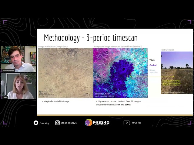
FOSS4G - Assessing cropland changes from violent conflict in central Mali with Sentinel
FOSS4G
29:25
FOSS4G - State of GDAL
FOSS4G
29:21
FOSS4G - The secret life of open source developers
FOSS4G
24:51
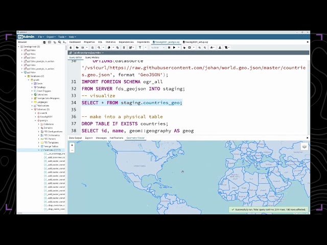
FOSS4G - Solving Spatial Problems with PostGIS
FOSS4G
27:11
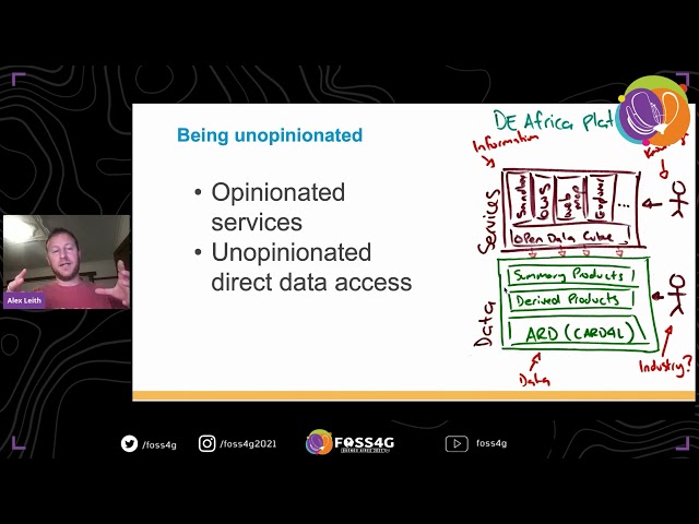
FOSS4G - Building Digital Earth Africa
FOSS4G
21:54
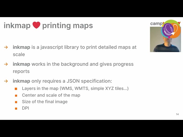
FOSS4G - Printing maps in the browser with InkMap
FOSS4G
31:24
FOSS4G - An introduction to the open access high resolution tropical forest data program
FOSS4G
25:06
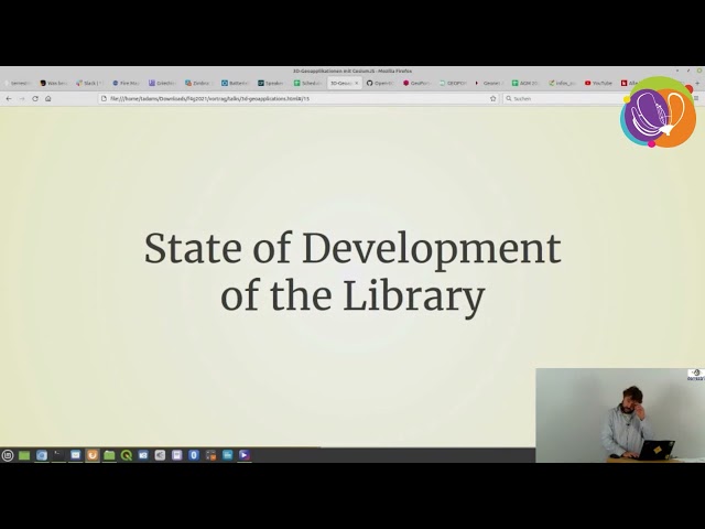
FOSS4G - 3D geo-applications with CesiumJS - data, possible use-cases and specifications
FOSS4G
29:30
FOSS4G - An Open Data Cube Sandbox using Google Colab
FOSS4G
21:35
FOSS4G - Enabling air pollution monitoring with Open Data Cube: implementation for Sentinel-5P
FOSS4G
30:30
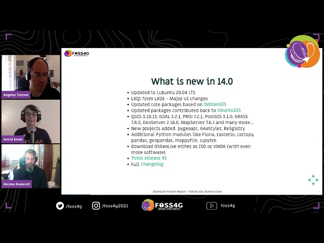
FOSS4G 2021 - OSGeoLive project report
FOSS4G
30:12
FOSS4G - Watching after your PostGIS herd
FOSS4G
24:45
FOSS4G 2021 - Professional multi-user editing with gvSIG Desktop
FOSS4G
28:00
FOSS4G - How to contribute - deegree developer and user meeting
FOSS4G
15:05
FOSS4G - Geostyler Mapfile Parser
FOSS4G
22:09
FOSS4G - Using game engines for 3D geospatial development
FOSS4G
32:38
FOSS4G - Geospatial Services for All: SERVIR’s Inclusive Approach to Service Design
FOSS4G
31:21
FOSS4G - LANDSLIDES MONITORING WITH TIME SERIES OF SENTINEL-1 IMAGERY IN
FOSS4G
28:26
FOSS4G - State of GRASS GIS: The Dawn of a New Era
FOSS4G
33:20
FOSS4G - Graph algorithms on the database with pgRouting
FOSS4G
24:21
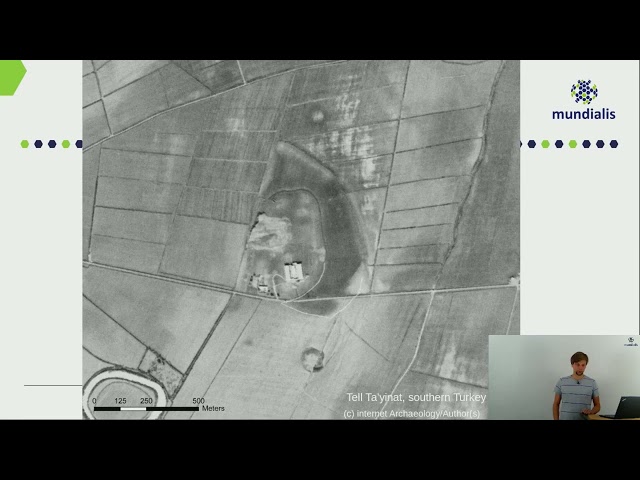
FOSS4G - Cold war reconnaissance imagery reloaded: orthorectifying the 1960s in high resolution
FOSS4G
30:45
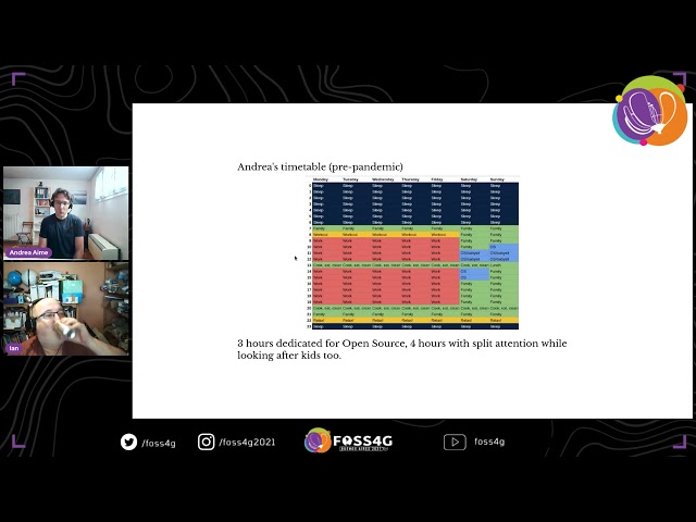
FOSS4G - Building Open Source Community in Pandemic
FOSS4G
27:17
FOSS4G - Handling GeoTIFFs in client-side code with GDAL and Loam
FOSS4G
19:52
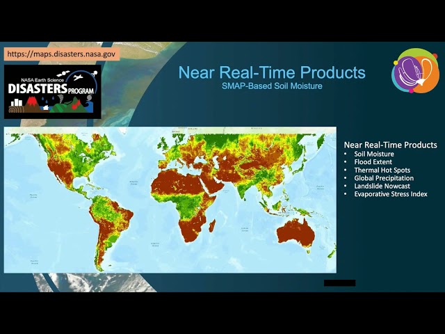
FOSS4G - Using NASA Earth Observations to Enable Open Science
FOSS4G
34:58
FOSS4G - Zaru: A New Platform for Real-Time Spatial Dashboards
FOSS4G
27:55
FOSS4G - A fast web 3D viewer for 11 million buildings
FOSS4G
29:00
FOSS4G - PgMetadata - A QGIS plugin to store the metadata of PostgreSQL layers inside the database
FOSS4G
21:58
FOSS4G - Going viral in the pandemic
FOSS4G
32:48
FOSS4G - Data Journalism and FOSS4G: Tools to face negationism and Pandemic
FOSS4G
25:06
FOSS4G - Forecasting the Future of Weather Data with GOES-R and TileDB
FOSS4G
31:06
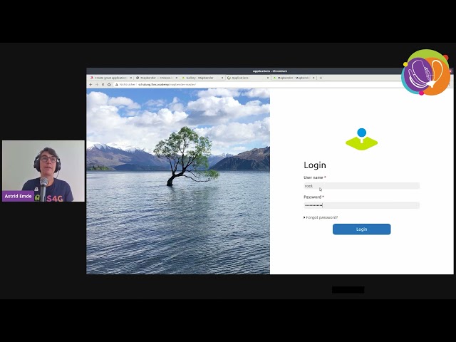
FOSS4G - Create great applications for you need with Mapbender
FOSS4G
27:47
FOSS4G - Leaflet: getting started with web mapping the easy way!
FOSS4G
29:05
FOSS4G - Development and prospects of Re:Earth, an open source GIS web app using Cesium
FOSS4G
37:34
FOSS4G - Mexican Geospatial Data Cube
FOSS4G
22:38
FOSS4G - Edusat: remote sensing as a learning material
FOSS4G
25:53
FOSS4G - ON THE FEASIBILITY OF APPLYING ORBITAL CORRECTIONS TO SAOCOM-1 DATA.....
FOSS4G
30:19
FOSS4G - pygeoapi: what's new in the Python OGC API Reference Implementation
FOSS4G
30:13
FOSS4G - API de OGC: antecedentes, estado actual, qué sigue
FOSS4G
32:08
FOSS4G - Provita Geoportal: a serverless GIS portal using the Jamstack
FOSS4G
30:22
FOSS4G - SMASH and Geopaparazzi, state of the art of the digital field mapping projects.
FOSS4G
26:22
FOSS4G - OpenStreetMap and the neglected pedestrian
FOSS4G
52:24
FOSS4G - Live coding: Leaflet web maps
FOSS4G
26:18
FOSS4G - GeoNetwork and Search Engine Optimization
FOSS4G
22:03
FOSS4G - BioPAL – Collaborative Open Source Software Development for ESA’s BIOMASS mission
FOSS4G
29:10
FOSS4G - Geospatial analysis using python 101
FOSS4G
28:29
FOSS4G - The Intersection of Geospatial Open Source and Commerce
FOSS4G
26:36
FOSS4G - Integrate Spatial Data in your business processes
FOSS4G
31:22
FOSS4G - OGC API - Deeper Dive into OGC API Features, Records and EDR
FOSS4G
19:47
FOSS4G - MapMint: The service-oriented platform
FOSS4G
19:18
FOSS4G - Enriched mobile apps for trails!
FOSS4G
23:05
FOSS4G - Transportation Engineering with FreeCAD
FOSS4G
1:02:21
FOSS4G - Live Coding Mapbox and React Apps with Typescript and Web Components
FOSS4G
29:02
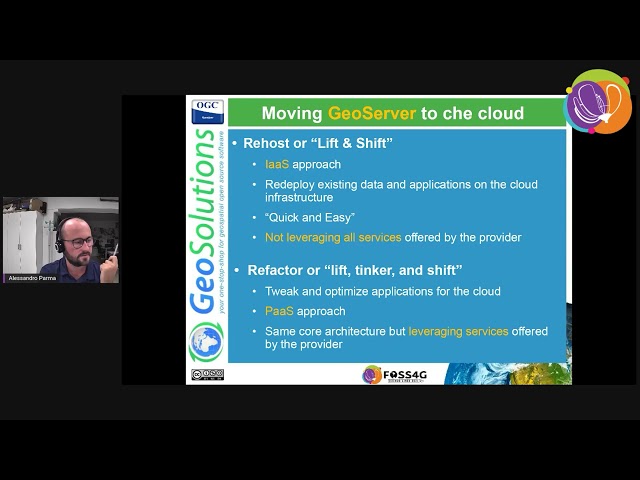
FOSS4G - Towards a better integration of GeoServer in a high-available cloud infrastructure
FOSS4G
29:09
FOSS4G - Beyond The Hype: One Year Running Addresscloud on 100% Serverless
FOSS4G
27:20
FOSS4G - Global Earth Monitor
FOSS4G
27:44
FOSS4G - Monitoring active fires in the Lower Paraná River floodplain: analysis and ...
FOSS4G
29:15
FOSS4G - Bringing language support to pygeoapi
FOSS4G
26:38
FOSS4G - QGIS and OGC APIs - how do they work together?
FOSS4G
28:38
FOSS4G - Seamless fieldwork thanks to QFieldCloud
FOSS4G
25:44
FOSS4G - Open Source and Mining: a roadmap
FOSS4G
28:27
FOSS4G - Al Accelerated Human-in-the-Loop schools and land use and land cover mapping
FOSS4G
26:18
FOSS4G - Remote Sensing and Modeling Tools Exploration for Habitat Delimitation of Leishmaniasis
FOSS4G
30:23
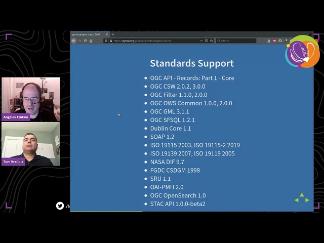
FOSS4G - pycsw project status 2021
FOSS4G
28:58
FOSS4G - A Multidisciplinary Exploration of FOSS
FOSS4G
22:01
FOSS4G - Modular OGC API Workflows for Processing and Visualization
FOSS4G
22:27
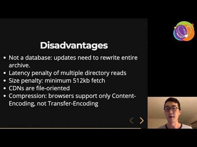
FOSS4G - PMTiles: An open, cloud-optimized archive format for serverless map data
FOSS4G
28:46
FOSS4G - MapLibre project: community driven Mapbox GL fork
FOSS4G
23:28
FOSS4G - Swissforages: the Free and Open-Source Borehole Data Management System
FOSS4G
59:34
FOSS4G - Live coding: WebGL shaders, rasters and symbols
FOSS4G
27:46
FOSS4G - Cloud optimized formats for rasters and vectors explained
FOSS4G
27:31
FOSS4G - GEE Timeseries Explorer for QGIS – Instant access to petabytes of Earth observation data
FOSS4G
31:04
FOSS4G - State of GeoNode
FOSS4G
35:09
FOSS4G - Low Cost and High Available Container-Based OGC Web Services for hosting OneGeology and ...
FOSS4G
22:08
FOSS4G - The Cloud Devoured Open Source
FOSS4G
24:59
FOSS4G - Building mobile apps with MapLibre SDK
FOSS4G
25:35
FOSS4G - An open-source geospatial workflow to map diverse landscapes in Pacific Island Countries
FOSS4G
32:39
FOSS4G - Towards the establishment of a new opensource geospatial remote sensing VRE
FOSS4G
25:05
FOSS4G - Land cover classification using freely available multitemporal SAR data (work in progress)
FOSS4G
27:30
FOSS4G - Presentation State of GeoNetwork
FOSS4G
31:43
FOSS4G - Cultural Heritage: a connecting factor between GEO engagement priorities
FOSS4G
33:04
FOSS4G - Demystifing OGC APIs with GeoServer: introduction and status of implementation
FOSS4G
33:51
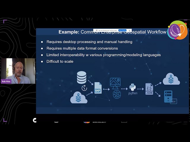
FOSS4G - Building Serverless Geospatial Applications for the Enterprise
FOSS4G
28:38
FOSS4G - Seamless fieldwork thanks to QFieldCloud
FOSS4G
23:39
FOSS4G EcoValuator: Basic Ecosystem Service Valuation for Custom Landscapes
FOSS4G
33:03
FOSS4G - Deploying and operating GeoServer: a DevOps perspective
FOSS4G
25:27
FOSS4G - Metadata Nirvana: Data discovery and metadata creation untouched by human hands
FOSS4G
23:45
FOSS4G - MapaTanda: Mapping for and with the Ageing Population
FOSS4G
24:07
FOSS4G 2021 - FOSS4G and the climate crisis: Let's get to work
FOSS4G
26:43
FOSS4G 2021 - A tool for machine learning based dasymetric mapping approaches in GRASS GIS
FOSS4G
27:07
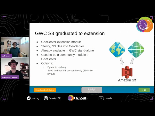
FOSS4G 2021 - State of GeoServer
FOSS4G
27:48
FOSS4G 2021 - The Very Best New Features of QGIS 3.x
FOSS4G
18:19
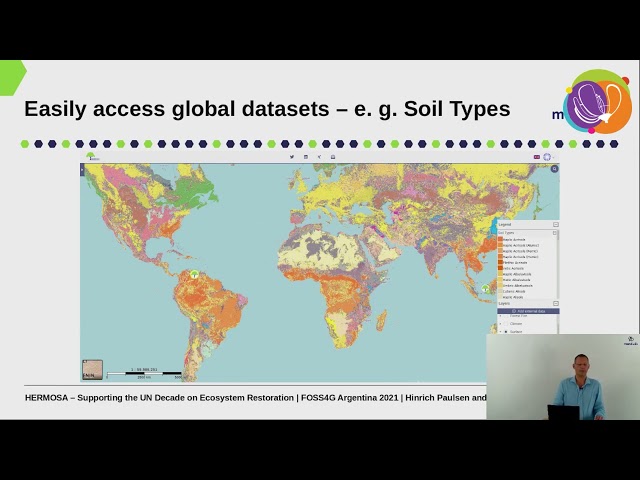
FOSS4G 2021 - HERMOSA: Supporting the UN decade on ecosystem restoration utilizing ..
FOSS4G
20:08
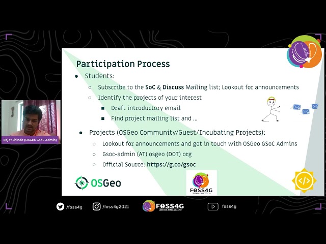
FOSS4G 2021 - Google Summer of Code with OSGeo
FOSS4G
30:46
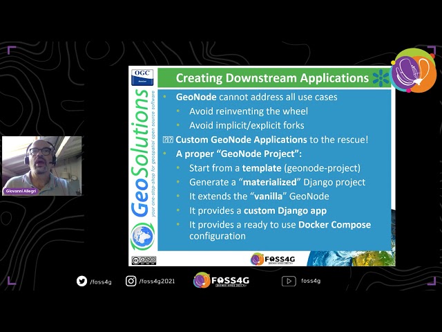
FOSS4G 2021 - One Geonode, many Geonodes
FOSS4G
24:59
FOSS4G 2021 - Deployment of open source vector tile technology with UN Vector Tile Toolkit
FOSS4G
24:38
FOSS4G 2021 - When Geometry meets Geography
FOSS4G
19:50
FOSS4G 2021 - I hated the way GRASS started so I changed it
FOSS4G
19:47
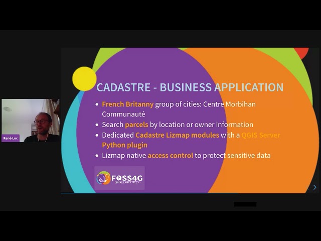
FOSS4G 2021 - Lizmap to create a Web Map Application with QGIS Desktop and Server
FOSS4G
1:12:44
FOSS4G 2021 - Women In Geospatial+: Career stories of women in FOSS4G
FOSS4G
20:20
FOSS4G 2021 - Curating machine learning datasets in international collaborations