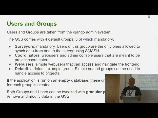
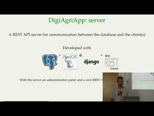
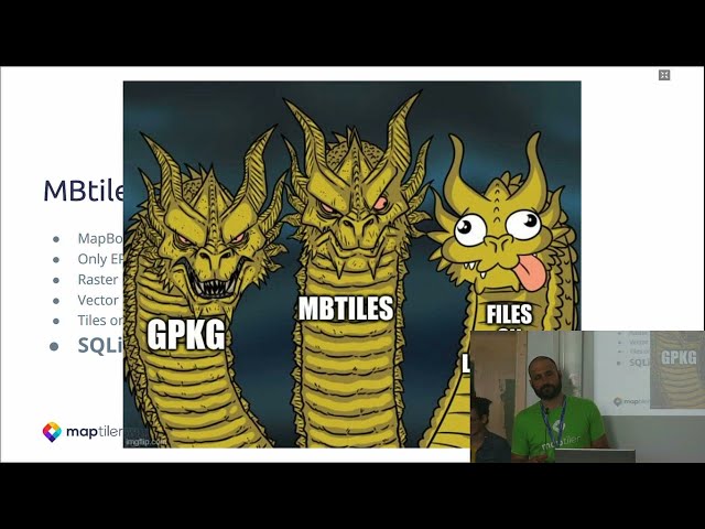
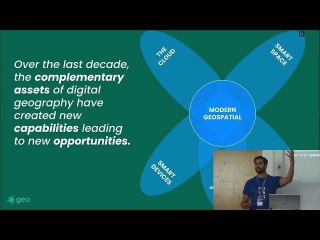
Author thumbnail

FOSS4G

FOSS4G 2023 Prizren Kosovo

2,556 views
279 items
Last updated on Oct 30, 2023
public playlist
2023 Keynote | The Importance of Seeding - from 3 ECTS to Shaping a better world - Marco Bernasocchi
19:38
2023 Keynote | Türkiye and Syria Earthquakes Mapping Response - Said Turksever
28:52
2023 Keynote | Geochicas: From SOTM to FOSS4G, a Geospatial journey - Miriam Gonzalez
23:39
2023 Keynote | Open-Source Solutions: Expanding our Humanity with Data Stories - Bonny McClain
56:08
2023 Keynote | Revolutionizing Solar Potential Assessments in Kosovo - Lorik Haxhiu
21:48
2023 Keynote |  Leveraging geospatial tech, UNICEF improves results for children - Jan Burdziej
38:53
2023 | SMASH and the new survey server - state of the art - Andrea Antonello
27:51
2023 |  DigiAgriApp: the app to manage your agricultural field - Luca Delucchi
29:43
2023 | Tiling big piles of raster data using open source software and MapTiler Engine - Jachym
28:43
2023 | Openness as a strategic advantage in modern geospatial - James Banting & Will Cadell
17:30
2023 |  IdeaMap Sudan - Building a geodata community in a data scarse context - Andre da Silva Mano
28:16
2023 | Community Activation for the Kahramanmaraş Earthquake Response via OpenStreetMap - Can Unen
33:27
2023 | Digitizing and improving GIS for Global Health - Céline Bassine
26:18
2023 | The template for a Semantic SensorThings API with the GloSIS use case - Luís M  de Sousa
21:51
2023 |  Tools for linking Wikidata and OpenStreetMap -Edward Betts
16:33
2023 | A Modern Nolli Map: Using OpenStreetMap Data to Represent Urban Public Spaces - Ester Scheck
14:48
2023 | Catasto-Open: open-source tools for the Italian Cadastre -Chiara Sammarco & Louis Andrianaivo
5:36
2023 | Mapping Japan cultural heritages with OpenSource based architecture - IGUCHI Kanahiro
5:34
2023 | Get your own OpenStreetMap dataset running in a Geoserver instance in 2 steps - Jose Macchi
5:58
2023 |  Why is popularity the biggest enemy of WMS? - Marcin Niemyjski
5:14
2023 | Evaluating geometric accuracy: Madagascar's 1:100,000 base map vs. CASEF ortho image.
4:32
2023 | Surface Runoff Processes and Design of Erosion Control Measure in Landscape&Artificial Slopes
6:20
2023 | Offline web map server "UNVT Portable" - Shogo Hirasawa
5:11
2023 |  eoAPI - The Earth Observation API - Vincent Sarago
4:01
2023 | Suomi.fi-maps - national service implementation with Oskari platform - Arto Sinkkonen
17:49
2023 |  State of Oskari - Sami Mäkinen
18:27
2023 | Oskari Embedded Maps and integrations with RPC API - Timo Aarnio
18:34
2023 | An Investigation in Updating the Building Stock Data for Municipalities in Baden-Württemberg
22:20
2023 | Investigating war crimes, animal trafficking, and more with open source geospatial data
22:06
2023 | Cartographic generalization with Open Source - Mathias Gröbe
16:56
2023 | Creating Global Edge-Matched Subnational Boundaries  - Maxym Malynowsky
16:53
2023 | "Map it! Cartographic interaction, user-map dialogue mediated by a computing device"
21:17
2023 | Cartographic design for vector tiles: Best practices and open-source recipes for maps
20:18
2023 | SOZip: using directly (geospatial) large compressed files in a ZIP archive! - Even Rouault
30:02
2023 | Overview of draft OGC Styles & Symbology "SymCore" 2.0 models & encodings - Jerome St Louis
27:16
2023 | Geo-Spatial meets Linked Data: open source solutions for semantic spatial data exchange
21:21
2023 |  Open resources and open standards for multi source marine twinning - Piotr Zaborowski
26:20
2023 | Demystifing OGC APIs with GeoServer: introduction and status of implementation  - Andrea Aime
20:55
2023 | How to secure pygeoapi and streamline protected OGC APIs - Francesco Bartoli
19:34
2023 |  Standardizing Satellite Tasking for Consumers - Matthew Hanson
17:03
2023 | Geo enabling your APIs with the location building blocks - Rob Atkinson
23:18
2023 |  The STAC JavaScript Ecosystem + CNG Excursion - Matthias Mohr
25:40
2023 | Earth-Search: A STAC API of Open datasets on AWS  - Matthew Hanson
18:11
2023 |  Standardized Data Management with STAC -Batuhan Kavlak & Sam Eglington
22:48
2023 | State of GeoRasterLayer (for Leaflet) - Daniel J  Dufour
24:17
2023 | An overview of Cloud-Native Geospatial - Matthew Hanson
18:18
2023 |  Get most out of STAC Browser - Matthias Mohr
20:00
2023 | Valhalla Routing Engine - Nils Nolde
25:33
2023 | GeoMapFish Project Status  - Yves Bolognini
15:00
2023 | Serverless Planet-scale Geospatial with Protomaps and PMTiles - Brandon Liu
17:59
2023 | MapStore, a year in review - Stefano Bovio
3:27
2023 |  Dynamic Tiling: From Cloud Optimized Raster to Map tiles - Vincent Sarago
20:32
2023 | Mapillary: The path to 2 billion images - Christopher Beddow & Edoardo Neerhut
22:52
2023 | Faster, easier, more powerful map tile creation with Tippecanoe 2.0 - Erica Fischer
12:39
2023 | TiPg: a Simple and Fast OGC Features and Tiles API for PostGIS  - Vincent Sarago
16:16
2023 | BikeDNA: A tool for Bicycle Infrastructure Data & Network Assessment - Anastassia Vybornova
13:29
2023 | A QGIS plugin for local weather sensor data - Emanuele Capizzi
4:24
2023 |  An Analysis of Capital Bikeshare Trips in Washington D.C. with Open-Source Geospatial Tools
17:39
2023 |  Synchronising data updates with Kart version control - Robert Coup
4:03
2023 | QGIS Data Versioning with Kart - Robert Coup
5:02
2023 | Visualization of accidental chemical release simulation - Kim Jinho
3:11
2023 | How I discovered, tested and fixed a bug in GeoDjango - Stefan Brand
4:47
2023 | Quality Assurance in open source: insights from GeoTools, GeoWebCache & GeoServer-Andrea Aime
19:36
2023 | Packaging Geospatial Software for Debian and Ubuntu Linux - Felix Delattre
21:47
2023 | Using Nix to build development environments as you always wanted - Ivan Minčík
27:30
2023 | Measuring Water Level Changes in Reservoir using Jason-3 Altimetry Mission - Aman Bagrecha
4:57
2023 | Algorithm Talk: How to Re-project a Raster at Warp Speed - Daniel J  Dufour
15:12
2023 |  Elephant in the room - Dennis Bauszus
17:35
2023 | OpenDataCube Fast Deploy using Docker (Fast Cubing) -J. R. Cedeno Jimenez
3:34
2023 | Development of maplibre applications in sveltekit  - Jin Igarashi
4:06
2023 | Application of FOSS4G for improving the environmental impact assessment process- Sanghee Shin
6:30
2023 | Collaborative mapping without internet connectivity - Volker Mische
22:08
2023 | Bulldozer, a free open source scalable software for DTM extraction - Dimitri Lallement
25:32
2023 | Site Calibration with PROJ and WKT2 - Javier Jimenez Shaw
19:24
2023 | End-to-end deep learning for boundary regularization & vectorization of building footprints.
13:35
2023 | Methods & challenges in time-series analysis of vegetation in  geospatial domain - Agata Elia
18:07
2023 | Traffic speed modelling to improve travel time estimation in openrouteservice
22:10
2023 | Developing FOSS4G Walkable Living Area Planning to Aid Korean 15-Minute City - Junyoung Choi
6:07
2023 | GIS-based intelligent system for infectious disease disaster response-  Min Young Lee
5:31
2023 | Fostering Knowledge Sharing through Interlinked Spatial Knowledge Graphs - Nathan McEachen
21:03
2023 | Mapping COVID-19 epidemic data using FOSS - Paolo Zatelli
5:11
2023 |  GeoServer Feature Frenzy - Andrea Aime & Jody Garnett
15:22
2023 |  GeoServer Cloud in depth - Gabriel Roldan
30:58
2023 | GeoServer Orientation and Demo - Jody Garnett
22:54
2023 | geoserverx - a new CLI and library to interact with GeoServer - Krishna Lodha
5:53
2023 | Integrated modeling with k.LAB... and QGIS - Andrea Antonello
19:52
2023 | Evaluation and assessment of open source projects - Tero Rönkkö
14:57
2023 | A Soft Transition to FOSS in a Decentral Administration - Thomas Marti & J.Wolfgang Kaltz
24:50
2023 | Land of 60000 zoning plans - QGIS to the rescue! - Ville Hamunen
19:10
2023 | Implementation of Statistical Geoportals in Latin America and the Caribbean - Walter Shilman
11:22
2023 | Open Data Analytics API in GeoNetwork - Gravin Florent
23:41
2023 |  ESA-NASA-OGC Open Science Persistent Demonstrator - Piotr Zaborowski
14:19
2023 | Processing & publishing Maritime AIS data with GeoServer and Databricks in Azure -Andrea Aime
17:40
2023 | MapComponents for your React application - Mathias Gröbe
13:35
2023 | Redmine Geo-Task-Tracker (GTT) Plugin - Taro Matsuzawa
21:41
2023 | Disaster Mapping Prioritization in OSM - Honey Fombuena
4:40
2023 | Offline web map server "UNVT Portable" - Taichi Furuhashi & Shogo Hirasawa
17:48
2023 | Smart Maps for the UN and All - keeping web maps open - Hidenori Fujimura & Yui Matsumura
23:48
2023 | UNDP's one stop shop for cloud based geospatial data visualisation and analytical tool
17:03
2023 | Geoconnex.us: a standards based framework to discover water data
14:07